
Rural Urban Classification 2021
The 2021 Rural Urban Classification (RUC) is a statistical classification which provides a consistent and standardised method for categorising geographies as either rural or urban according to data from the 2021 Census.
Background
The 2021 Rural Urban Classification (RUC) is a way of classifying an area as either rural or urban according to data from the 2021 Census. The classification is based on:
- address density
- physical settlement form
- population size
- relative access to major towns and cities (populations of over 75,000 people).
The classification has been applied to local authority districts and statistical geographies including Middle Super Output Areas, Lower Super Output Areas and Output Areas. This marks a change from the 2011 classification which was also applied to upper tier authorities, parliamentary constituencies and electoral wards.
The classification uses quite a different methodology to the RUC which the ONS used in 2011, and a comparison between the different methodologies can be seen below.
Classification of districts
Local authority district classifications are divided into four categories based on their populations:
- Majority Rural: had at least 50% of their population residing in rural Output Areas
- Intermediate Rural: 35-50% of their population residing in rural Output Areas
- Intermediate Urban: 20-35% of their population residing in rural Output Areas
- Urban: 20% or less of the population residing in rural Output Areas
Each category is then split into one of two relative access categories. If more than 50% of a district’s population lives ‘Nearer a major town or city’ Output Area, it is deemed ‘nearer a major town or city’; otherwise, it is classified as ‘further from a major town or city’. None of the districts of East Sussex are classed as ‘Further from a major town or city’.
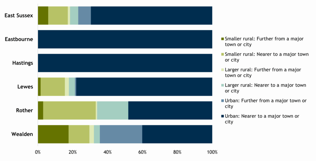
2021 Rural Urban Classification of East Sussex districts
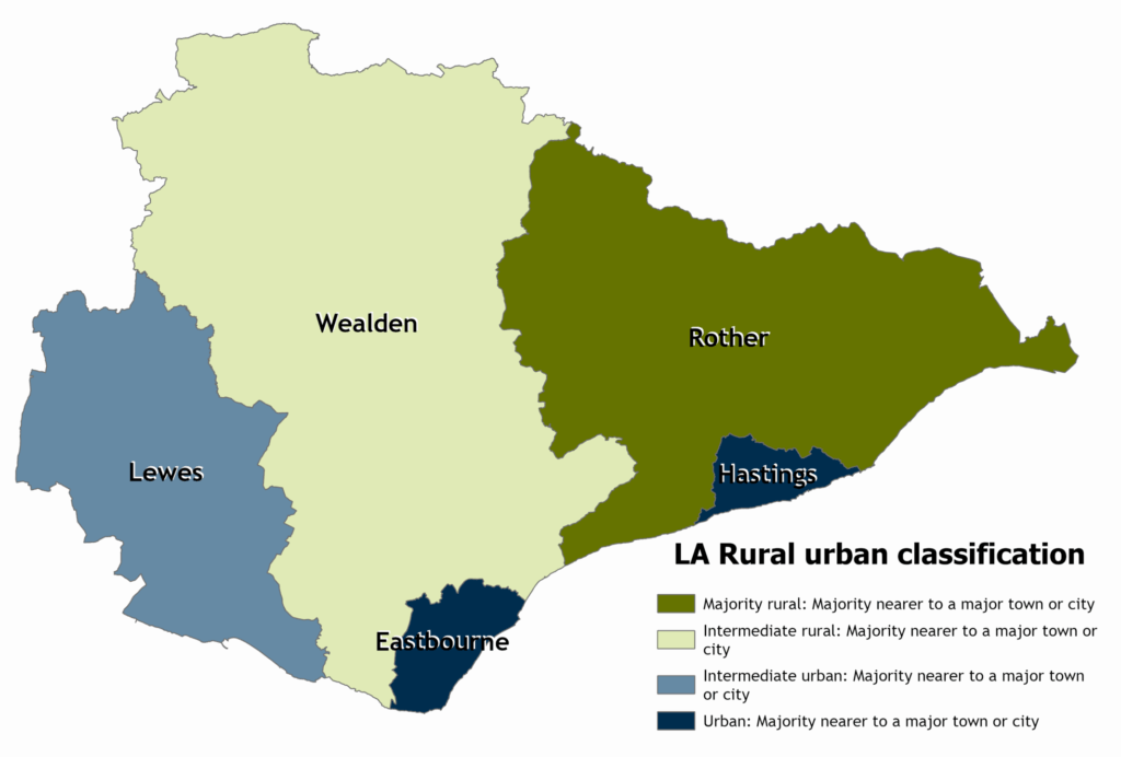
East Sussex’s districts are classified as follows:
- Eastbourne and Hastings: Urban: Majority nearer to a major town or city
- Lewes: Intermediate urban: Majority nearer to a major town or city
- Rother: Majority rural: Majority nearer to a major town or city
- Wealden: Intermediate rural: Majority nearer to a major town or city
Classification of small areas
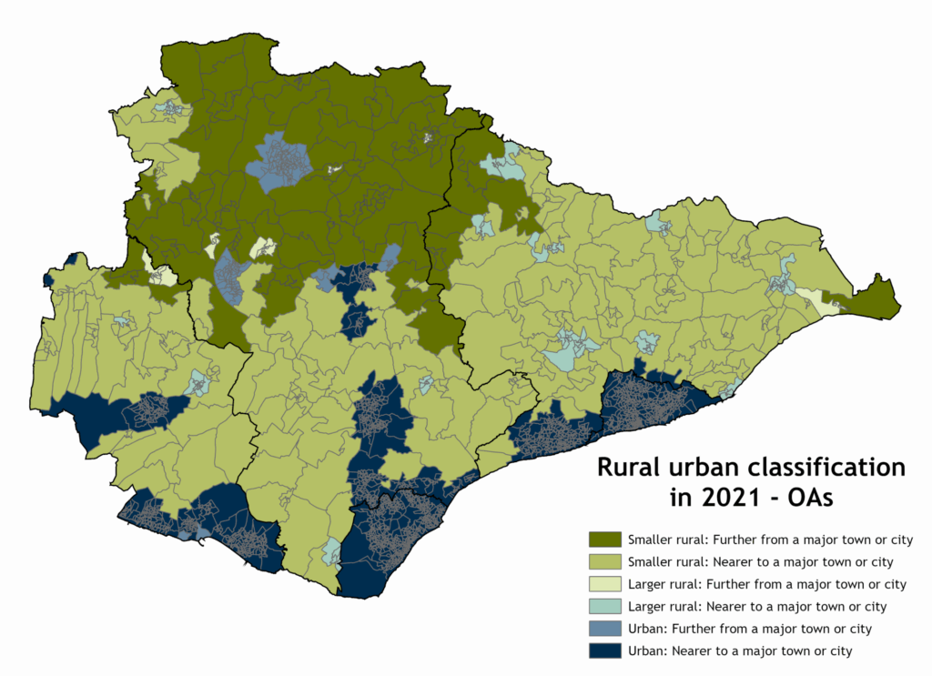
A more detailed view of variations across districts is shown below – for output areas, Lower layer super output areas (LSOAs) and Middle layer super output areas (MSOAs). This is based on the classification of Output Area geographies. Output Areas are defined as urban if they have a high density of residential addresses, or if they intersect with Amalgamated Built Up Areas (ABUAs) with a resident population of 10,000 or more. ABUAs are Built Up Areas (BUAs) within 200m of one another and with a direct road connection, representing larger conurbations. Output Areas that intersect with ABUAs with populations less than 10,000, or that have lower densities of addresses, are assigned to larger or smaller rural settlement categories. All Output Areas are also distinguished by whether they are nearer to or further from a major town or city. The classification consists of:
Rural
- Smaller Rural: Further from a major town or city
- Smaller Rural: Nearer to a major town or city
- Larger Rural: Further from a major town or city
- Larger Rural: Nearer to a major town or city
Urban
- Urban: Further from a major town or city
- Urban: Nearer to a major town or city
Not unsurprisingly all the Output Areas in Eastbourne and Hastings have been classified as urban, the remaining districts are made up of a combination of urban and rural classifications.
Detailed Rural/urban classification of Output Areas in East Sussex
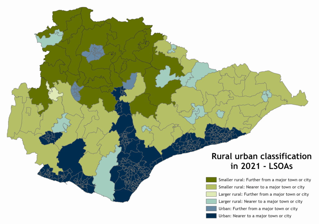
When we compare the classification of Output Areas with Lower Layer Super Output Areas (LSOAs), a larger proportion of the county appears to be classed as “Urban”. This is most noticeable in Lewes 004D (around Firle/Beddingham), areas in the Hailsham/Polegate corridor north of Eastbourne, and in the west of Bexhill in Rother.
Detailed Rural/urban classification of Lower Layer Super Output Areas (LSOAs) in East Sussex
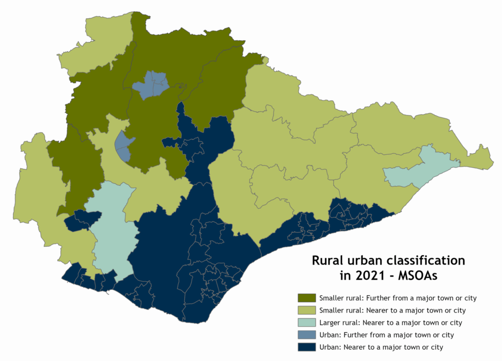
When we compare the classification of Lower Layer Super Output Areas (LSOAs) with MSOAs, an even larger proportion of the county appears to be classed as “Urban”. This is most noticeable in areas north and west of Eastbourne, but also in Heathfield and the area around it.
Detailed Rural/urban classification of Middle Layer Super Output Areas (MSOAs) in East Sussex
Area by rural/urban classification
The rural and urban classification can then be used to analyse population and other data, to allow comparisons between rural and urban areas. An analysis of East Sussex shows that 85% of the area of the county contains Output Areas (OAs) which are categorised as Rural.
The proportion of area of East Sussex (85.0%) covered by rural OAs is higher than both England as a whole (83.5%) and the rest of the South East (78.5%). When we look at district level, at 95.2%, Rother has the joint highest proportion of area covered by rural OAs in the South East region, together with South Oxfordshire.
Percentage of area that is in rural Output Areas

Population by rural/urban classification
In 2021 77% of the county’s total population lived in urban Output Areas and 23% in rural output areas. 17.5% live in smaller rural areas, and 6.0% live in larger rural areas. The picture in the districts more complex. In Rother, 51.9% live in a rural area, with 33.2% in smaller rural areas, and 18.7% in larger rural areas. In Wealden, 35.5% live in a rural area, but while a similar proportion to Rother live in smaller rural areas, 29.6%, only 5.9% live in larger rural areas. Wealden has the highest proportion living in an Urban area that is further from a major town or city (24.3%), while Rother has no population in areas in that category.
Percentage of population of East Sussex by detailed RUC type
Percentage of population of East Sussex districts living in rural areas
| Total population in 2021 | Rural population | % Rural | |
| Eastbourne | 101,700 | 0.0% | |
| Hastings | 90,980 | 0.0% | |
| Lewes | 99,920 | 21,280 | 21.3% |
| Rother | 93,130 | 48,320 | 51.9% |
| Wealden | 160,120 | 56,910 | 35.5% |
| East Sussex | 545,850 | 126,510 | 23.2% |
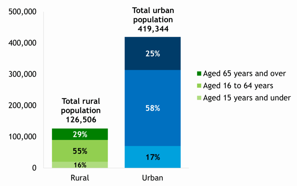
Age groups
While in 2021, 26% of the total population of the county were aged 65 and over, 29% of the rural population were in this age group. By comparison, when we look at younger age groups, while 58% of people in urban areas were aged 16-64, 55% of rural dwellers were working age. 17% of Urban dwellers were children age 0-15, compared to 16% or the rural population.
Percentage of urban and rural population of East Sussex by broad age groups
Percentage of urban and rural population of East Sussex districts by broad age groups

Comparison with 2011 Rural Urban classification
It is not possible to compare the 2021 Rural Urban classification with the classification which ONS produced in 2011.
The 2021 RUC has several changes from the 2011 version, which result from:
- Changes in the underlying data sources used for the RUC due to increased availability and quality of data.
- Changes to the methodology used for the RUC – including simplification of the classification for clarity, improvements to how density is measured in coastal areas, harmonisation of the method across geographical scales and the replacement of ‘Sparsity’ with ‘Relative Access’ measures – which has led to the most dramatic changes in the county.
- Physical changes in the environment over the last decade.
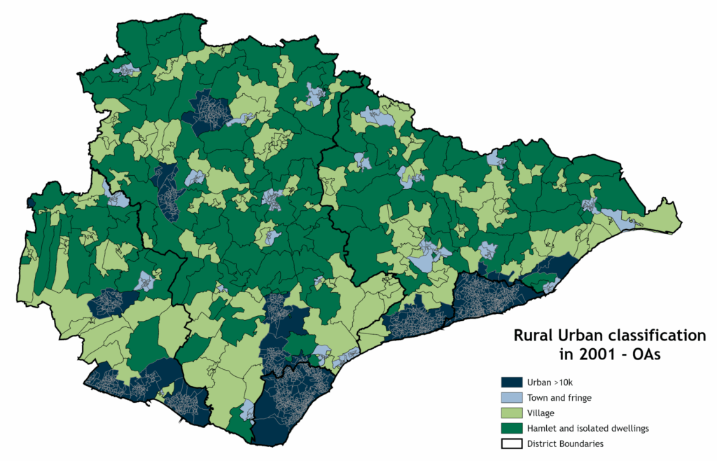
These changes have led to significant changes in the way areas are classified. The distribution of rural output areas in 2011 across the county was very different to how they appear in 2021 (2001 also included below for comparison):
Output areas by Rural Urban classification in 2001, 2011 and 2021
2001
2011
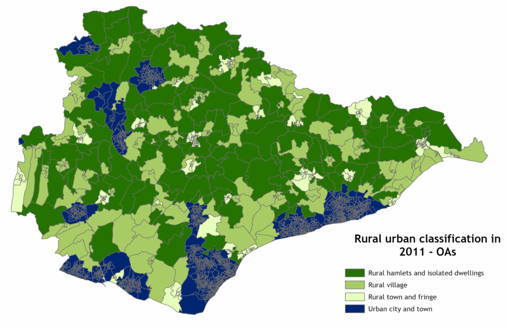
2021
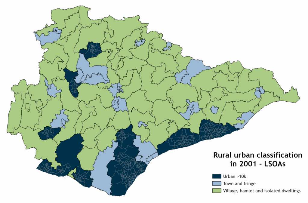
Likewise, the way LSOAs are classified in 2021 is radically different from the way they were classified in 2011. None of the LSOAs in East Sussex were classified as “Rural hamlets and isolated dwellings” in 2011.
LSOAs by Rural Urban classification in 2001, 2011 and 2021
2001
2011
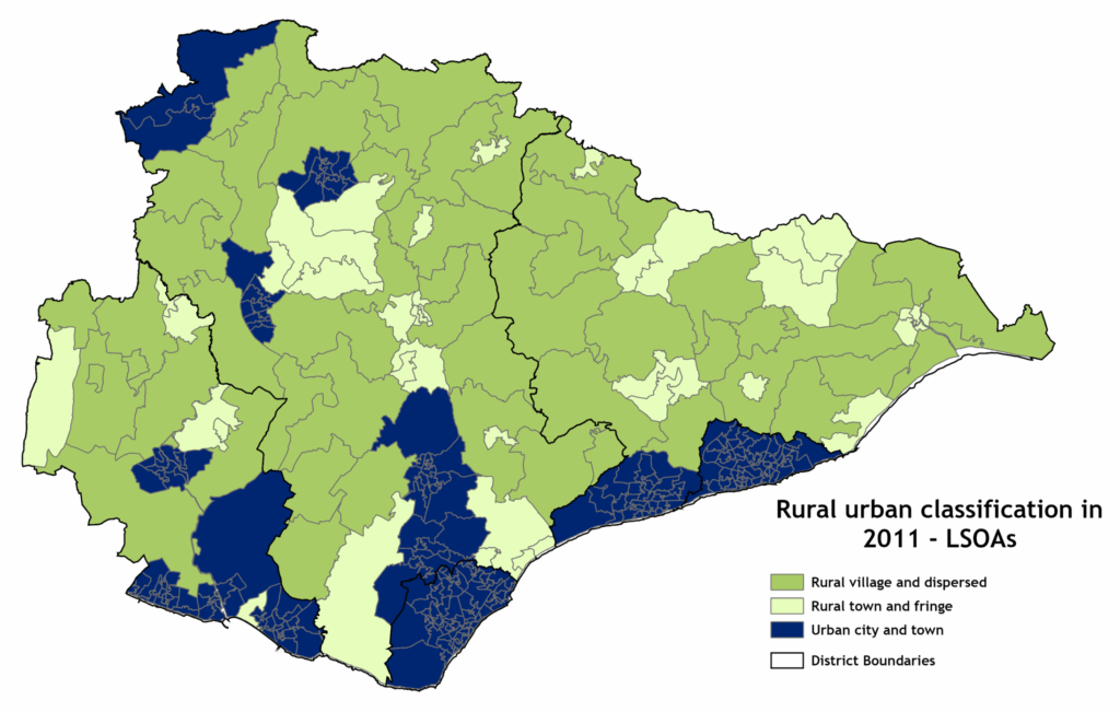
2021
Further information
You can find a detailed analysis of the changes since 2011 in this document from the ONS: Rural-Urban Classification (2021) Frequently Asked Questions.
Detailed lookup tables for Output Areas (OAs), Lower layer super output areas (LSOA) and Middle layer super output areas (MSOA) are available as a MS Excel workbook here: RUC lookup tables (.xlsx, 82kb). Use the filter on the appropriate worksheet to select all rural LSOAs, for example. You can then copy paste a list of rural LSOAs into the custom geography tool to see detailed characteristics of rural areas, For any support or guidance on how to do this, please contact the R&I team using the email below.
PDF maps of Output Areas (OAs) (pdf, 2.4 MB), Lower layer super output areas (LSOAs) (pdf, 846 KB), Middle layer super output areas (MSOAs) (pdf, 554 KB) and districts (pdf, 282 KB) are available.
The Research and Intelligence Team, Governance Services, provides demographic and socio-economic data, intelligence and insight to support East Sussex County Council and other East Sussex Partners. The Team also manages East Sussex in Figures (ESiF), the Local Information System for East Sussex.
Contact esif@eastsussex.gov.uk for more information about the Rural Urban classification.